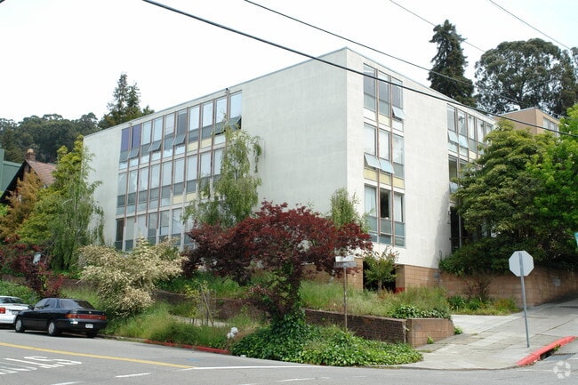
Property Record
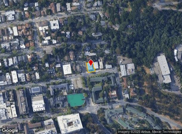
2701 Ridge Rd, Berkeley, CA 94709

NEARBY LISTINGS FOR SALE OR LEASE
Property Detail
2701 Ridge Rd
Oakland-Fremont-Berkeley, CA
Daleys Scenic Park
058-2204-008-01
LOT: 00001 BLK: 0008 AR: 0058 PAGE: 2204
Multifamilydwelling
Alameda
X
California
06013C0244G
1-3
2024
0.15 AC
2025
North Berkeley
422500
East Bay/Oakland
10,404 SF
DEMOGRAPHICS near 2701 Ridge Rd
1 Mile
3 Mile
5 Mile
2024 Total Population
46,092
190,028
358,891
2029 Population
45,035
184,808
350,424
Pop Growth 2024-2029
(2.29%)
(2.75%)
(2.36%)
Average Age
32
40
41
2024 Total Households
15,436
75,016
148,721
HH Growth 2024-2029
(2.11%)
(2.88%)
(2.44%)
Median Household Inc
$61,530
$109,981
$112,319
Avg Household Size
2.10
2.20
2.20
2024 Avg HH Vehicles
1.00
1.00
1.00
Median Home Value
$1,092,746
$1,097,637
$1,079,602
Median Year Built
1959
1949
1954
Nearby Places
Map Layers
Map Styles
 Street
 Aerial
- Restaurants
- Banks
- Shops
- Fitness
- Groceries
PUBLIC TRANSPORTATION
TRANSIT/SUBWAY
Downtown Berkeley Station (Fremont - Richmond - Bay Area Rapid Transit (BART), Richmond - Millbrae - Bay Area Rapid Transit (BART))
DRIVE
WALK
Distance
Downtown Berkeley Station (Fremont - Richmond - Bay Area Rapid Transit (BART), Richmond - Millbrae - Bay Area Rapid Transit (BART))
4 min
18 min
0.9 mi
COMMUTER RAIL
DRIVE
WALK
Distance
9 min
2.7 mi
DRIVE
WALK
Distance
13 min
4.0 mi
AIRPORT
Metro Oakland International
DRIVE
WALK
Distance
Metro Oakland International
26 min
15.3 mi
San Francisco International
DRIVE
WALK
Distance
San Francisco International
43 min
25.7 mi
Nearby Properties
Address
Land Use
TOTAL SIZE
Lot Size
Zoning
Address
Land Use
TOTAL SIZE
Lot Size
Zoning
358,014 SF
5.03 AC
Address
Land Use
TOTAL SIZE
Lot Size
Zoning
167,071 SF
0.70 AC
Address
Land Use
TOTAL SIZE
Lot Size
Zoning
540,434 SF
14.37 AC
Address
Land Use
TOTAL SIZE
Lot Size
Zoning
395,549 SF
17.05 AC
Address
Land Use
TOTAL SIZE
Lot Size
Zoning
250,642 SF
17.05 AC
Address
Land Use
TOTAL SIZE
Lot Size
Zoning
261,134 SF
2.23 AC
Address
Land Use
TOTAL SIZE
Lot Size
Zoning
169,157 SF
10.20 AC
Address
Land Use
TOTAL SIZE
Lot Size
Zoning
224,160 SF
5.03 AC
Address
Land Use
TOTAL SIZE
Lot Size
Zoning
4.77 AC
Address
Land Use
TOTAL SIZE
Lot Size
Zoning
309,451 SF
0.87 AC
Address
Land Use
TOTAL SIZE
Lot Size
Zoning
60,670 SF
1.57 AC
Address
Land Use
TOTAL SIZE
Lot Size
Zoning
123,750 SF
0.81 AC
Address
Land Use
TOTAL SIZE
Lot Size
Zoning
254,000 SF
1.71 AC
Address
Land Use
TOTAL SIZE
Lot Size
Zoning
127,260 SF
5 AC
I
Address
Land Use
TOTAL SIZE
Lot Size
Zoning
131,862 SF
1.19 AC
Address
Land Use
TOTAL SIZE
Lot Size
Zoning
166,731 SF
0.54 AC
Address
Land Use
TOTAL SIZE
Lot Size
Zoning
111,710 SF
15.47 AC
Address
Land Use
TOTAL SIZE
Lot Size
Zoning
134,608 SF
1.15 AC
Address
Land Use
TOTAL SIZE
Lot Size
Zoning
86,144 SF
0.52 AC
Address
Land Use
TOTAL SIZE
Lot Size
Zoning
137,102 SF
3.63 AC
Address
Land Use
TOTAL SIZE
Lot Size
Zoning
159,705 SF
1.64 AC
COMM
Address
Land Use
TOTAL SIZE
Lot Size
Zoning
65,839 SF
0.62 AC
C2
Address
Land Use
TOTAL SIZE
Lot Size
Zoning
0.61 AC
Address
Land Use
TOTAL SIZE
Lot Size
Zoning
3.61 AC
Address
Land Use
TOTAL SIZE
Lot Size
Zoning
90,594 SF
2.06 AC
Address
Land Use
TOTAL SIZE
Lot Size
Zoning
30,500 SF
0.24 AC
R4
Address
Land Use
TOTAL SIZE
Lot Size
Zoning
0.60 AC
Address
Land Use
TOTAL SIZE
Lot Size
Zoning
67,558 SF
0.32 AC
Address
Land Use
TOTAL SIZE
Lot Size
Zoning
136,811 SF
1.01 AC
Address
Land Use
TOTAL SIZE
Lot Size
Zoning
45,500 SF
1.79 AC
The World's #1 Commercial Real Estate Marketplace
Connect with us
© 2026 CoStar Group
The information above has been obtained from sources believed reliable. While we do not doubt its accuracy we have not verified it and make no guarantee, warranty or representation about it. It is your responsibility to independently confirm its accuracy and completeness. Any projections, opinions, assumptions, or estimates used are for example only and do not represent the current or future performance of the property. The value of this transaction to you depends on tax and other factors which should be evaluated by your tax, financial, and legal advisors. You and your advisors should conduct a careful, independent investigation of the property to determine to your satisfaction the suitability of the property for your needs.